Snow
Snow Introduction
Snowfall Remote Sensing
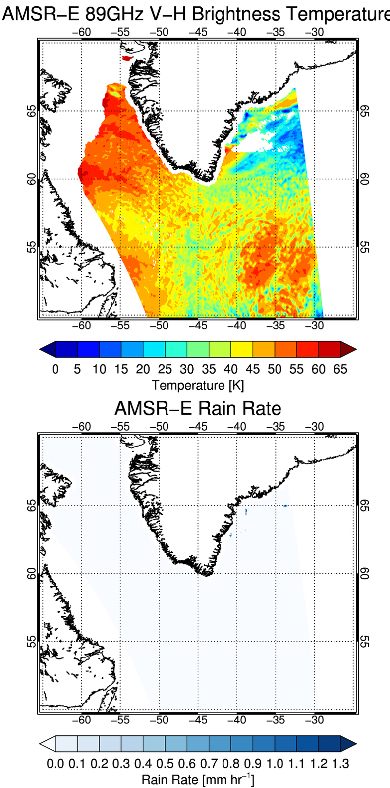
Radar is one of the primary tools for observing precipitation, including snowfall, but only a small fraction of the Earth’s surface is observed by ground-based weather radars. In recent years, satellite-borne radars and passive microwave radiometers have become important tools for producing near-global observations of snowfall and we are actively investigating methods for interpreting these observations. Although some regions of the globe receive upwards of 40% of their annual snow from shallow cumuliform clouds, conventional satellite-based radar and radiometer algorithms struggle to identify such light, near-ground snowfall (Figure X, radiometer showing shallow snowing clouds [regions with cellular, red/orange structure]; Figure Y, precipitation detection algorithm shows no snowfall).
Our researchers analyze combined observations from CloudSat, AMSR-E, and vertically-pointing ground-based radars to quantify the amount of snowfall that goes undetected by remote sensing systems and work to improve this problem. We are the principal developers for CloudSat’s snowfall retrieval product (2C-SNOW-PROFILE) and continue to investigate advanced remote sensing methods for snowfall. This work is funded by the NASA CloudSat, Precipitation Measurement Mission (PMM), and the Aerosols-Clouds-Ecosystems (ACE) missions. Through a collaboration with the University of Utah in an effort funded by the Department of Energy’s Atmospheric Systems Research program, we are developing new datasets for snowfall process studies using ground-based vertically-pointing Ka-band radars located at Atmospheric Radiation Measurement program observatories.
Global Snowfall in Observations, Models, and Reanalyses
On a global scale, we evaluate the ability of observations, reanalyses, and climate models to characterize snowfall in a variety of situations. One particular challenge is estimating snowfall in complex topography, a factor that is difficult to resolve in both models and observations. We are investigating this challenging problem under a seed grant from the University of Wisconsin Center for Climatic Research. Another interesting complication is shallow cumuliform snowfall, which tends to produce less snowfall but can be a significant contributor to accumulation in specific regions; our group has uncovered a notable bias that exists between shallow cumuliform snow in reanalysis and observational products. This work is funded by NASA.
Future Satellite Missions
Recent advances in spaceborne precipitation radars have broadened our viewing area and increased the number of observations in any given area. However, these radars still struggle to reconcile the light snowfall that comes from shallow clouds. While the accumulation may not be substantial compared to a midlatitude blizzard, in places like Barrow, AK, much of the falling snow comes from clouds less than 1km deep and with reflectivities of less than 0 dBZ. Those limits place important requirements on future spaceborne radars if they are to reliably detect frozen precipitation. Using high-resolution radars based on the ground (ARM) or on airplanes (IPHEx, OlympEx campaigns), we quantify the effects of degrading radar resolution and sensitivity to multiple radar wavelengths. This knowledge determines the trade-space of instrument characteristics necessary for program managers of agencies like NASA and NOAA to define the next radar(s) in space. This work is funded by NASA and DOE.
Microphysics of Frozen Particles
A deeper understanding of snow microphysics is crucial in developing observing systems, remote sensing methods, and snowfall data products because microphysical properties of snow profoundly influence both bulk snow properties and the relationship between these properties and measurements made by remote sensing instruments like radars and radiometers. For snow, these relationships are complex because of the extreme variability of snow particle shapes and size distributions. We analyze intensive ground- or aircraft-based snow observations to determine how particle properties (mass, fall speed, concentration) vary with environment and particle size, then translate these data into relationships which can be applied in remote sensing algorithms and in models ranging in scale from weather systems to global climate. This work is funded by the NSF and NASA. (Figure: (top) snowflake images from the Multi-angle Snowflake Camera; (bottom) measurements showing changes in snowflake sizes over time from the Precipitation Imaging Package)


