High Clouds and Convection
High Clouds and Convection Introduction
Deep convection and high-altitude clouds are key components of Earth’s water cycle and exert a strong influence on radiative balance and water cycle. Our research explores the global distribution and radiative forcing from high clouds as well as their connection to the water cycle. We strive to gain a deeper understanding of cloud microphysical properties through remote sensing observation. The work presented on this page is realized under National Aeronautics and Space Administration (NASA) and National Science Foundation (NSF) support.
The Effects of High Clouds and Convection
Vertical Structure of Deep Convection Over the Continental United States
To understand the various processes in convection, we are studying how local thermodynamic controls, such as convective available potential energy (CAPE), relative humidity, surface heat, and moisture fluxes, influence the relationship between the water cycle and radiative impacts of continental convection in CloudSat-PATMOS merged datasets.
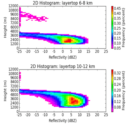
To complement this work, by allowing rainfall processes to be examined, we are developing a Bayesian rainfall retrieval framework for CloudSat over land by utilizing a collocated along-track CloudSat-NEXRAD dataset. In the future, the analysis will include radiative effects of certain combinations of rain rate and layer top height. The frequency of CloudSat observed reflectivity, composited by layer top height will form the basis for this new CloudSat dataset. An example of this decomposition is presented at the right with 2D histogram plots.
Relationship Between High Clouds and Stratospheric Water Vapor
Cirrus clouds are ubiquitous in the tropics, and are known for their net positive radiative forcing. They are also linked to the amount of water vapor entering the stratosphere. It is crucial to accurately characterize the microphysical properties of ice clouds, since they determine the way in which these clouds interact with radiation and the atmosphere. We are interested in using satellite observations to determine any existing relations between cloud properties, water vapor, and temperature, as well as optimizing the methods with which we obtain cloud properties through satellite observations.
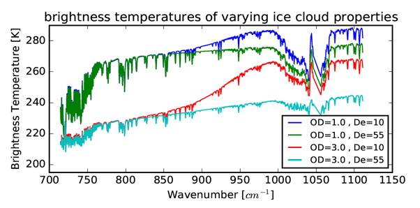
To optimize the use of satellites along the A-Train constellation, we are developing an algorithm to estimate ice cloud properties using combined measurements from AIRS, MODIS, CloudSat and CALIPSO. We take advantage of model simulations to analyze which observation combinations will offer the most information about clouds. The next figure shows the simulated AIRS brightness temperatures for different cloud optical depths and effective diameters.
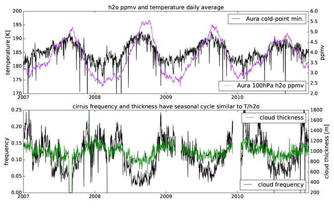
This information is being used to characterize the properties of tropical tropopause layer (TTL) cirrus and understand their relationship to stratospheric water vapor. Near the tropical tropopause, air slowly upwells into the stratosphere through the tropical tropopause layer. This region often has extremely low temperatures, forcing water vapor to sediment as ice clouds. We are interested in the characteristics of these clouds, as they are closely linked with the amount of water vapor entering the stratosphere. Temperature and water vapor amount is known to correlate well with each other, and cirrus frequency is also known to inversely correlate with temperature. Furthermore, it is possible that cloud properties, such as cloud thickness, are also connected to this variability. These links are highlighted in the figure below that shows time series of cold-point temperature and water vapor (top) from Aura MLS and cirrus frequency and thickness (bottom) from the 2c-ice datasets derived from CloudSat/CALIPSO.