Field Work
Field Work Introduction
The first step toward understanding the weather and climate of Earth is to make observations. Real-world measurements are used throughout the atmospheric sciences; from case studies of individual storms to building and evaluating theoretical models that predict the future global climate. The L’Ecuyer Research Group is continually involved in field campaigns, both large and small, to obtain these measurements that will ultimately be used by the broader scientific community to better understand our environment.
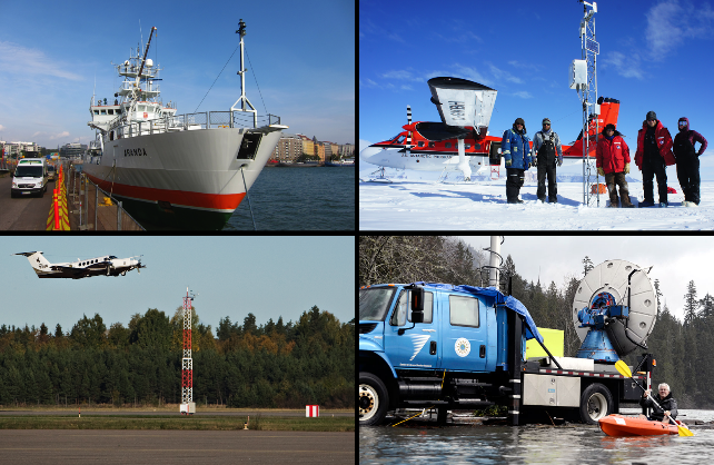
The above image shows just a few of the various observational platforms that we use. Ship-based (top-left) and aircraft (bottom-left) measurements were taken during the Light Precipitation Validation Experiment (LPVEx) program. It was an international collaboration between the United States, Finland and Canada to evaluate and improve satellite precipitation estimates at high latitudes. In situ and remote measurements of liquid and frozen precipitation from the ground, aircraft, and satellites were collected in the vicinity of Helsinki, Finland from Sept. 15 - Dec. 31, 2010. A surface climatology over the Antarctic ice sheet is obtained by careful installation and ongoing maintenance of weather stations (top-right) by the Antarctic Meteorological Research Center (AMRC) and their Automatic Weather Station (AWS) program. A mobile doppler radar (bottom-right) was utilized during another satellite validation program, the Olympic Mountains Experiment (OLYMPEX), which ran from November 1, 2015 to January 17, 2016 in the Pacific Northwest United States.
Below are additional highlights from current and past projects L’Ecuyer Group members are/were involved in.
ORACLES

The ObseRvations of Aerosols above CLouds and their intEractions (ORACLES) field experiment is a multi-institution effort aimed at resolving cloud & aerosol interaction discrepancies among climate models. The experiment location - the southeast Atlantic Ocean - is the perfect testbed for this because of the collocation of a seasonal biomass burning layer and semi-permanent stratocumulus cloud deck. Among the 20+ instruments aboard the NASA P-3 aircraft include a High Spectral Resolution Lidar (HSRL), the 3rd generation Airborne Precipitation Radar (APR-3), Phased Doppler Interferometer (PDI), and a Spectrometer for Sky-Scanning, Sun-Tracking Atmospheric Research (4STAR). Data collected from this experiment will help answer many long-standing scientific questions, such as the role of aerosols in precipitation suppression as well as direct measurements of aerosol radiative effects and heating rates. The ORACLES experiment will take place again in October 2018.
Figure caption: The ORACLES 2017 science and instrument teams in front of the NASA P-3 aircraft. Image credit: Johnny Zavaleta
Snow-Focused Field Experiments
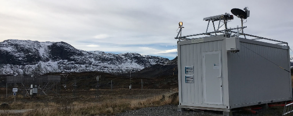
Successfully assessing snow's role in Earth's energy and water cycles depends fundamentally on quantifying the basic microphysical properties of snow and relating the processes that form these particles to the larger dynamical environment. Our current efforts involve detailed measurements of snow properties using ground-based in situ and remote sensing measurements, including video disdrometers, profiling radar and high-resolution imaging supplemented by measurements such as precipitation and meteorology provided by collaborators. In addition, we work to analyze similar data sets from field experiments conducted by other research programs. The expected sensitivity of higher latitude regions to climate change and the important role snowfall plays in these regions makes them important locations for our research, and recent deployments of the instrumentation have been made in remote southern Norway and in far northern Sweden above the Arctic Circle.
HiLAMS webpage: https://lecuyer.aos.wisc.edu/snowfall-obs/
Figure caption: Snow instruments deployed in the Telemark region of Norway in collaboration with the Norwegian Meteorological Institute.
Group-Involved Field Campaigns
- First Complex Layered-Cloud Experiment (CLEX): June, 1996 - July, 1996. Oklahoma, USA.
- NOAA Climate Monitoring and Diagnostics Laboratory, Baseline Observatory program: 1998 - 2001. Mauna Loa, Hawaii; South Pole station, Antarctica.
- Canadian CloudSat/CALIPSO Validation Project (C3VP): December, 2006 - March, 2007. Ontario, Canada (in conjunction with the 10th Complex Layered-Cloud Experiment).
- Light Precipitation Validation Experiment (LPVEx): September, 2010 - December, 2010. Southern Finland.
- GPM Cold Season Precipitation Experiment (GCPEx): January, 2012 - March, 2012. Ontario, Canada
- Integrated Precipitation and Hydrology Experiment (IPHEx): May, 2014 - June, 2014. North and South Carolina, USA (in conjunction with the Radar Definition Experiment, RADEX)
- Olympic Mountain Experiment (OlympEx): November, 2015 - February, 2016. Washington, USA (in conjunction with RADEX)
- ObseRvations of Aerosols above CLouds and their intERactionS (ORACLES): August - September, 2016; August-September, 2017; September - October, 2018. Namibia, Sao Tome & Principe, and the southeastern Atlantic ocean.
- High Latitude Measurements of Snow (HiLaMS): October, 2016 - June, 2017. Southern Norway; October, 2017 - June, 2018. Northern Sweden.
- Elin McIlhattan (2014-15 field season) and Marian Mateling (2017-18 field season) travelled to Antarctica to assist the Antarctic Meteorological Research Center (AMRC) install and maintain their automated weather station network.