Scientific Objectives
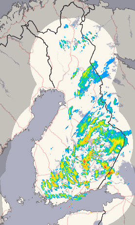
The Light Precipitation Evaluation Experiment (LPVEx) planned for the Gulf of Finland in September and October, 2010 will seek to address this shortcoming by collecting microphysical properties, associated remote sensing observations, and coordinated model simulations of high latitude precipitation systems to drive the evaluation and development of precipitation algorithms for current and future satellite platforms. Specifically, LPVEx seeks to characterize the ability of CloudSat, the Global Precipitation Mission (GPM) Dual-frequency Precipitation Radar (DPR), and existing/planned passive microwave (PMW) sensors such as the GPM microwave imager (GMI) to detect light rain and evaluate their estimates of rainfall intensity in high latitude, shallow freezing level environments. Through the collection of additional microphysical and environmental parameters, the campaign will also seek to better understand the process of light rainfall formation and augment the currently limited database of light rainfall microphysical properties that form the critical assumptions at the root of satellite retrieval algorithms. Specific science questions include:
- What are the minimum rainrates that can be detected by current satellite precipitation sensors in environments with shallow freezing levels (lower than 2 km)? How will rainfall detection be improved by proposed future platforms?
- How well can these sensors discriminate rain from falling snow?
- Are the microphysical assumptions, such as raindrop size distribution, cloud water contents, and properties of the melting layer and precipitating ice aloft, currently employed in global satellite precipitation algorithms representative of high latitude precipitation in a statistical sense?
- What is the impact of variability in these microphysical assumptions and those related to vertical structure and spatial inhomogeneity on random errors in retrieved rainfall rate?
- Collectively, are the above inter-sensor differences large enough to explain the wide spread in current satellite estimates of high-latitude rainfall?
Radar: Loading